Unifying NASA Earth Science Data Discovery
Connecting fragmented NASA data experiences while implementing the Horizon Design System across Earthdata.

The Challenge
NASA’s Earthdata platform brings together Earth science data from multiple Distributed Active Archive Centers (DAACs), many of which had operated independently for more than a decade with their own navigation patterns, terminology, and dataset page structures.
I led the end-to-end design of a unified data product experience that consolidated fragmented dataset discovery pathways into a more consistent, intuitive system within Earthdata.
My Work
User Research: Interviews, workflow mapping, content audit
Design: Wireframes, design system implementation, prototyping
Collaboration and Project Management: Stakeholder alignment, facilitating design reviews and iterative feedback sessions
My Role
Senior UX Designer
Our Team
Project Manager
3 Developers
Designer (me)
Software
Figma
Section 508 Accessibility
Drupal

Key Outcomes
Through research-driven design, cross-functional collaboration, and implementation of NASA’s Horizon Design System, the work improved consistency, simplified complex scientific workflows, and established a stronger foundation for future Earthdata growth.
Unified Discovery Experience
Researchers can now navigate a more cohesive experience across datasets, collections, and related resources that previously existed across disconnected DAAC sites. The redesign created clearer pathways for discovering and accessing Earth science data within a centralized Earthdata ecosystem.
Scalable Design Framework
The project established reusable patterns and flexible templates that could support a wide variety of scientific disciplines and dataset types. By leveraging the Horizon Design System, the designs created greater consistency while remaining adaptable to DAAC-specific needs and workflows.
Improved Data Access Clarity
Standardized layouts, clearer terminology, and more intuitive organization helped simplify complex technical content and data access methods. The redesigned pages made it easier for users to understand how to explore, configure, and download datasets.
Cross-Team Alignment
The work brought together stakeholders across multiple DAACs, UX, content, and development teams to align around shared patterns and user experience goals. This collaborative process helped modernize long-standing legacy experiences while building consensus across independently operated systems.
Process and Solutions
I selected three methods of discovery to serve as the foundation for initial designs with user flow mapping and content auditing to understand the space and interviews to validate the findings. Additional input from Google Analytics and previous usability reports were incorporated into my final synthesis based on gaps in the research and additional questions.

User Flow Mapping
-
Investigate how users are currently finding data
-
Look for commonalities and opportunities to provide familiar pathways for users
-
Identify different data product related content types across the DAAC sites

Content Inventory
-
Conduct a content audit of a sample of DAAC dataset pages
-
Compare to ensure the new dataset pages include the right level of information for users and accounts for the variety of types of dataset pages

Interviews
-
Learn from the DAACs how their users are finding data, what’s working well and what they might like to see change
-
Validate DAAC user flow maps and pages for the content inventory
Pathways to Accessing Data
Research showed that users accessed Earth science data through many different pathways depending on their experience level, goals, and familiarity with specific DAACs. Because these systems had evolved independently over time, navigation structures and discovery workflows varied significantly across the Earthdata ecosystem.
The flow mapping exercise revealed both common discovery behaviors and fragmented experiences between DAACs. Experienced users often navigated directly to known datasets, while newer users relied more heavily on browsing, filtering, and guided discovery pathways.

User flow mapping across DAACs illustrating the variety of pathways researchers use to discover and access datasets.
From the flow analysis and stakeholder interviews, I identified several primary pathways users relied on to find and access data across Earthdata.
These findings informed the redesign of navigation and discovery patterns across Earthdata, including:
-
More consistent terminology and labeling
-
Stronger connections between related datasets and resources
-
Support for multiple discovery workflows instead of a single prescribed path
-
Improved pathways between search, browse, and direct dataset access experiences

Key dataset discovery pathways synthesized from user flow mapping and stakeholder research.
Individual Dataset Landing Pages
A cross-DAAC content inventory revealed that while dataset landing pages shared many of the same core pieces of information, they differed significantly in structure, terminology, formatting, and download workflows. Many pages had evolved independently over years, creating inconsistent experiences for users navigating across Earthdata.

Content inventory comparing dataset landing pages across multiple DAACs to identify shared patterns, inconsistencies, and unique requirements.
The inventory helped identify which content types were consistently important to users, such as metadata, citations, and access information, as well as where layouts and terminology diverged. This analysis became the foundation for defining scalable page structures and shared content patterns.
From the inventory analysis, I synthesized the findings into three categories: consistent fields, inconsistently implemented fields, and DAAC-specific features requiring flexible design support.
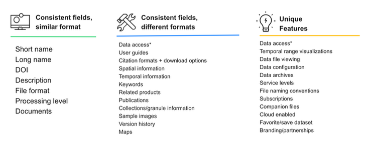
Synthesized dataset page field analysis used to guide standardized templates and flexible component design.
These findings directly informed the final dataset page designs, including:
-
A standardized tabbed layout for organizing complex technical content
-
Reusable Horizon Design System components
-
Clearer data access and citation patterns
-
Flexible templates capable of supporting diverse scientific datasets while maintaining consistency across Earthdata
Simplified Access to NASA Earth Science Data
The final designs created a more unified and scalable experience for discovering and accessing Earth science data across NASA Earthdata. By combining consistent navigation patterns, flexible dataset templates, and Horizon Design System components, the new pages helped simplify complex technical information while still supporting the diverse needs of individual DAACs and scientific disciplines. The result was a more intuitive experience that improved clarity, strengthened connections between related data products, and established a foundation for future Earthdata growth and modernization.


