Unifying NASA Earth Science Data Discovery
Designing a scalable data discovery ecosystem for one of the world's largest collections of Earth science information.

The Challenge
NASA’s Earthdata platform brings together Earth science data from multiple Distributed Active Archive Centers (DAACs), many of which had operated independently for more than a decade with their own navigation patterns, terminology, and dataset page structures.
The challenge was not simply helping users find data, but helping them understand what data existed, determine whether it met their needs, and identify the best path to access it. I led the end-to-end design of a unified data product experience that consolidated fragmented dataset discovery pathways into a more consistent, intuitive system within Earthdata.
My Role
Senior UX/UI Designer
Our Team
Project Manager
3 Developers
Designer (me)
Software
Figma
Section 508 Accessibility
Drupal
My Work
User Research: Interviews, workflow mapping, content audit
Design: Wireframes, design system implementation, prototyping
Collaboration and Project Management: Stakeholder alignment, facilitating design reviews and iterative feedback sessions

Key Outcomes
Through research-driven design, cross-functional collaboration, and implementation of NASA’s Horizon Design System, the work improved consistency, simplified complex scientific workflows, and established a stronger foundation for future Earthdata growth.
Unified Discovery Experience
Created a more connected ecosystem that helps users move seamlessly between datasets, tools, applications, and supporting resources.
Scalable Information Architecture
Established patterns capable of supporting thousands of datasets and future growth across the Earthdata ecosystem.
Improved Dataset Evaluation
Helped users more quickly understand what data exists, whether it meets their needs, and how to access it.
Cross-Team Alignment
Created a shared framework for organizing and presenting Earth science resources across multiple NASA programs and teams.
Discovery
To understand the challenges users faced when navigating the Earthdata ecosystem, I employed a mixed-methods discovery approach that combined user flow mapping, content auditing, and stakeholder interviews. Together, these methods provided both a systems-level view of how information was organized and a user-centered understanding of how people actually searched for, evaluated, and accessed data. Insights from Google Analytics and previous usability studies were used to validate findings, fill knowledge gaps, and strengthen the final recommendations.

User Flow Mapping
-
Investigate how users are currently finding data
-
Look for commonalities and opportunities to provide familiar pathways for users
-
Identify different data product related content types across the DAAC sites

Content Inventory
-
Conduct a content audit of a sample of DAAC dataset pages
-
Compare to ensure the new dataset pages include the right level of information for users and accounts for the variety of types of dataset pages

Interviews
-
Learn from the DAACs how their users are finding data, what’s working well and what they might like to see change
-
Validate DAAC user flow maps and pages for the content inventory
Understanding Data Discovery Workflows
One of the first challenges was understanding how users navigated the increasingly complex Earthdata ecosystem. With thousands of datasets, tools, applications, and supporting resources available, users could enter the experience from many different starting points.
To better understand these behaviors, I mapped the primary pathways users followed to discover and access Earth science data. Drawing from stakeholder interviews, existing documentation, and ecosystem analysis, I identified how users moved between datasets, applications, topic pages, documentation, and search experiences, as well as the key decision points encountered along the way.

User flow mapping across DAACs illustrating the variety of pathways researchers use to discover and access datasets.
I then facilitated workshops with stakeholders across the Earthdata program to validate these workflows, identify gaps, and build alignment around a shared understanding of the user journey. These discussions helped refine the pathways, uncover additional discovery behaviors, and prioritize opportunities for improvement.
The resulting framework revealed that data discovery was not a linear process but a network of interconnected journeys. These insights informed navigation and information architecture decisions across Earthdata, including stronger connections between related resources, more consistent terminology, and support for multiple discovery pathways rather than a single prescribed route.

Key dataset discovery pathways synthesized from user flow mapping and stakeholder research.
Individual Dataset Landing Pages
A cross-DAAC content inventory revealed that while dataset landing pages shared many of the same core pieces of information, they differed significantly in structure, terminology, formatting, and download workflows. Many pages had evolved independently over years, creating inconsistent experiences for users navigating across Earthdata.

Content inventory comparing dataset landing pages across multiple DAACs to identify shared patterns, inconsistencies, and unique requirements.
One of the most significant challenges users faced was determining whether a dataset was relevant before investing time in downloading or analyzing it.
To support this evaluation process, I explored ways to surface key metadata, contextual information, related resources, and access options directly within dataset experiences. The goal was to help users make informed decisions more quickly while reducing the effort required to understand complex scientific data products.
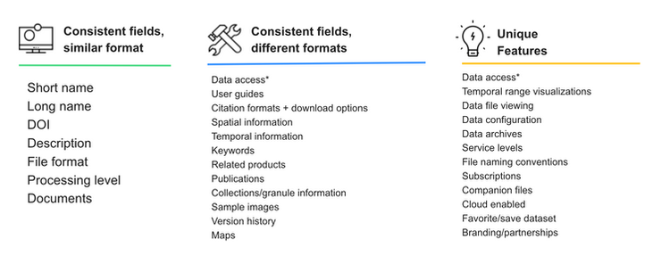
Synthesized dataset page field analysis used to guide standardized templates and flexible component design.
Rather than presenting metadata as a comprehensive reference, the experience prioritized the details users needed to quickly answer questions about dataset relevance, spatial and temporal coverage, resolution, access methods, and provider information. The Earthdata team has since expanded this work into an interactive guide that helps users better understand the purpose and value of each metadata element on dataset landing pages.
By organizing metadata around user goals instead of repository structure, the redesigned landing pages reduced cognitive effort, improved dataset evaluation, and created clearer pathways from discovery to data access. They also established a scalable pattern that could be applied consistently across thousands of Earth science datasets within the Earthdata ecosystem.

Simplified Access to NASA Earth Science Data
The final concepts reimagined Earthdata as a connected discovery ecosystem rather than a collection of individual resources. By improving relationships between datasets, applications, topics, and supporting content, the experience helps users more easily discover, evaluate, and access the Earth science information needed to answer complex questions about our planet.


